Why ecologists are now using UKHab surveys
You may have noticed that ecologists and consultancies are moving away from the use of the JNCC Phase 1 habitat survey methodology to conduct habitat surveys and are instead using the newer UK Habitat (UKHab) Classification Working Group methodology. The UKHab classification system was released back in 2018 and it has since seen a near industry wide uptake for using this methodology, including Wild Frontier Ecology.
UKHab is a much newer classification system compared to JNCC’s Phase 1 with the last edition published in 1992. Legislation, policies, industry standards and mapping have changed considerably in that time and the UKHab classification system now provides a more modern and simple classification tool relevant for the present day. UKHab also has a greater variety of habitat types available for the surveyor to classify habitats compared to the older Phase 1 classifications. For example, there are 29 different primary codes for grassland with different categories covering lowland and upland grasslands. There is no longer a ‘semi-improved grassland’ category which will be familiar to those who previously used the Phase 1 classifications.
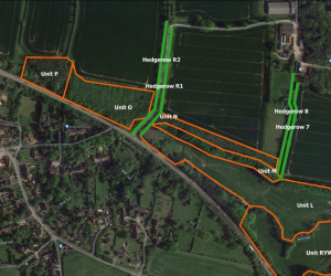
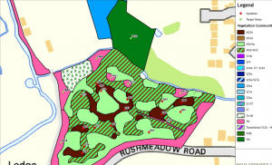
Producing habitat maps within GIS is a key part of Wild Frontier Ecology’s work and UKHab is designed for producing maps within GIS. This easily helps us to produce detailed habitat maps for our clients, which becomes slightly trickier if you’re using the Phase 1 classifications as it was designed for producing maps with paper and colouring pencils. UKHab has a standardised symbology much like Phase 1, which makes the habitat maps easy to interpret.
Biodiversity Net Gain was enshrined in law within the Environment Act 2021 and is expected to become mandatory for all large development projects in November 2023. To produce a Net Gain assessment for a proposed development the practitioner must use DEFRA’s Biodiversity Metric. The Biodiversity Metric uses the UKHab classification methodology and it is one of the main reasons why many ecology practitioners have switched to using UKHab. It saves time for ecologists to use UKHab, as otherwise all habitats classified using Phase 1 will need to be reinterpreted to use DEFRA’s Biodiversity Metric.
Though there are many benefits to UKHab it is not perfect and will likely be continually updated in response to the feedback from ecologists and other practitioners.


