skip to Main Content

Wintering bird surveys in an SPA

  • January 27, 2020
  • Blog

WFE was commissioned to undertake a study of foraging wintering birds on the River Deben Estuary SPA (Special Protection Area) in Suffolk, focusing on a particular area where a freshwater flow was pumped from a sluice at night into the river from surrounding arable land. Natural England were concerned that plans to redirect this waterflow away from the estuary may impact non-breeding waterfowl species such as brent goose and redshank for which the Deben is an internationally important site. Water birds have been found to preferentially associate with freshwater flows over mudflats due to accessibility of fresh water for bathing and drinking and an increase in invertebrate prey densities.

wintering bird surveys

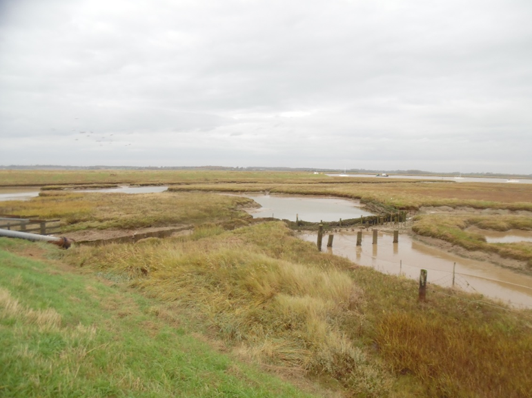
The River Deben is an internationally important site for bird species such as redshank and brent goose

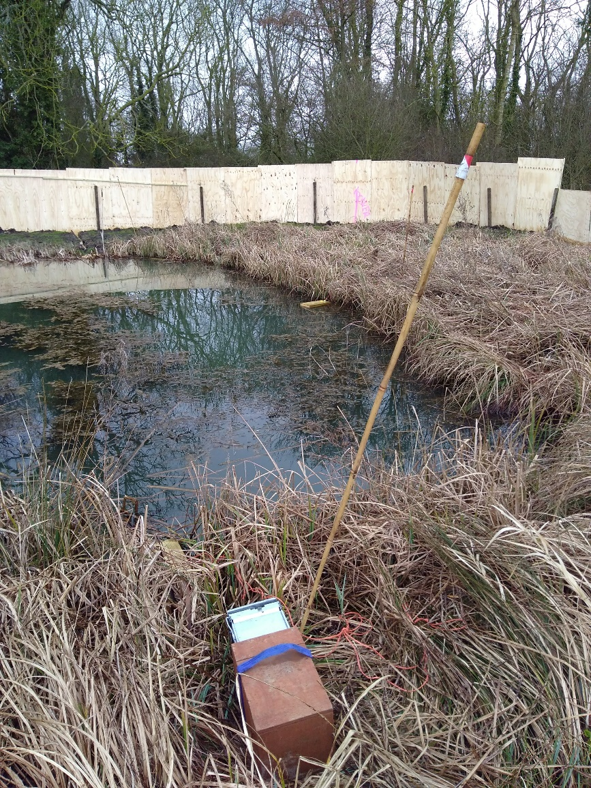
The study compared the ornithological importance of the outfall site, which has intermittent flowing freshwater, with two control sites, one comprised an area of mudflat with no freshwater influence, while the other control was an area of mudflat with a permanent freshwater gravity flow. Two nocturnal surveys and one daylight survey were conducted per month between November and March on all three areas and involved the counting and identifying all bird species present with the assistance of thermal imaging cameras.

The study discovered that the area with the permanent freshwater flow hosted a significantly greater density of birds than the other two sites, which both had a very similar density of birds associated with both the nocturnal surveys and diurnal surveys. It was concluded that the site with the intermittent freshwater water flow had a negligible influence on the local bird communities providing equivalent habitat to a creek with no freshwater input and therefore the removal of the water flow would have no negative impacts on the wintering bird populations listed as interest features of the Deben Estuary SPA.

A new water pipeline at Thetford

  • January 27, 2020
  • Blog

In 2018 Wild Frontier Ecology undertook an extended Phase 1 habitat survey along a proposed water pipeline route around Thetford in Norfolk. The route was proposed to go through an industrial estate, agricultural fields, pastures, grasslands, hedges and trees.

To assess the habitats along the route, and the potential for any impacts on protected species, Wild Frontier Ecology first carried out a desk survey. This comprised a search for conservation sites within 2km of the proposed route and a data search with the Norfolk Biodiversity Information Service for species records. Fourteen statutorily designated nature conservation sites and 16 County Wildlife Sites were found with three of the County Wildlife Sites directly intersecting the route. 6,450 species records, including reptiles and a variety of bird species were also found within the 2km buffer.

Next the route was subject to a walkover survey where all habitats within a 100-250m buffer of the proposed pipeline were mapped and considered for their potential to host protected species such as great crested newts, reptiles and stone curlews. Ponds were also recorded and assessed for their suitability for great crested newts.

phase 1 water pipeline

An excerpt of a Phase 1 Habitat Map for the pipeline route

Based on the findings of the habitat survey, the client was advised that further great crested newt, reptile and stone curlew surveys should be undertaken to ensure impacts on these species were fully considered. No great crested newts were found in any of the surveyed ponds, a population of grass snakes was recorded at one County Wildlife Site and a stone curlew nest recorded just to the north of the route.

phase 1 water pipeline

Adam contemplates an early bath

Subsequent advice on how to avoid the recorded ecological features allowed the client to opt for directionally drilling under the County Wildlife Sites.

Wild Frontier’s final report then summarised the anticipated ecological impacts for the purposes of planning. Tailored construction methods and seasonal restrictions to the work were advised based on the survey findings. Altogether the package of survey works and clear practical advice meant that the project was assessed to have a neutral ecological impact in the long term, fulfilling the client’s ecological obligations.

Ecological mitigation for a coastal grassland site

ecological mitigation coastal grassland

Broom flowering on the existing site

A brownfield site in North Norfolk is planned to accommodate a small housing development. It was surveyed by WFE and found to have a good quality semi-improved coastal-type grassland in parts of the site, including such species as spring vetch, rest-harrow and abundant common knapweed. As the grassland was determined to be neutral rather than acid or chalky, it was not considered to be a Priority Habitat. However, the case was put to the developer that the grassland was worth saving, to which the developer agreed.

There was no room on the developed site to accommodate the grassland, and the site is not well ecologically connected. It was considered that offsite compensation would be the only realistic option. A mitigation plan was put together in consultation with the county ecologist. The plan is to translocate turves and seed from the grassland to a site a few miles along the coast to try to establish it in a similar coastal location. The scheme has full support of the landowner, and is due to take place in 2020. Watch this space for updates!

ecological mitigation coastal grassland

Receptor site for seed and turves

Bats in a barn conversion

bats barn conversion Adam

Adam installs a receptor bat box on a tree as part of the mitigation for a bat EPS licence

As part of the works under a bat EPS licence, WFE provided an ECoW service for the conversion of a barn complex in Hindolveston, Norfolk in 2018.  Survey work over the summer of 2017 identified the presence of common pipistrelle, soprano pipistrelle and brown long-eared bat roosts within the barns.

The ECoW service included a “Toolbox Talk” to contractors prior to commencement of works on the site to ensure awareness of protected species issues and their responsibilities while working on the site, direct supervision of sensitive works, and consultation to ensure the correct installation of mitigation and compensation measures on site.

During the course of the supervised hand-stripping of roof tiles from the barns, two roosting bats were encountered; one common pipistrelle and one brown long-eared bat.  On each of these occasions the Natural England bat licensed ECoW was on hand to

bats barn conversion pip

A common pipistrelle was safely translocated during an Ecological Clerk of Works supervised roof strip

carefully remove the bat from the works site, give it a health check and relocate it to a receptor bat box in a suitable location elsewhere on site. 

Due to the effective ECoW service provided this project ran smoothly in accordance with the terms and conditions of the EPS licence, resulting in the prevention of harm to roosting bats and effective mitigation and compensation measures being implemented.


Bats revealed in a building inspection

WFE was commissioned to inspect a former Methodist chapel and associated buildings in Norwich for bats. A previous inspection by another consultant had found no bats, but small amounts of droppings in the roof void of the main chapel building. The consultant had concluded a development licence would not be required in view of the works undertaken, but the plans had since changed to include intrusion into the roof void. 

bats building inspection

A brown long eared bat roosting on the ridge beam

The exterior of the buildings was inspected by eye, with a full photographic record made. The complex nature of the building layout meant that certain parts could only be viewed by ascending exterior ladders to view roof sections. On the inside, the very high internal ceilings resulted in long ladder climbs, but the roof voids were largely boarded out.

The main roof void contained a single brown long-eared bat, characteristically roosting on the ridge beam. The finding of the bat gave client some certainty in terms of a timetable for renovation of the building and helped to clarify the licencing requirements for the development.

Bats in a listed building

WFE was commissioned to complete bat surveys of a former college complex in North Norfolk, following a building inspection which identified moderate and low bat potential in a number of buildings. The buildings were a mixture of different designs and ages, with a part being Grade II listed, and careful thought was needed to achieve efficient deployment of surveyors and recording equipment. We also surveyed a single tree which was due to be felled in the plans.

bat surveys listed building

Old bat droppings in a roof void

Surveyors, thermal imagers and static bat detectors were used over a period of several weeks to conduct two emergence or dawn return surveys on each building. Audio and video results were subsequently analysed, along with surveyors’ field sheets to make sure all bat emergences were both recorded and not double-recorded. 

The surveys located day-roosts of common pipistrelles in some of the buildings, and a soprano pipistrelle roost in the tree. Brown long-eared bats were seen on the activity surveys, but no roost could be located in the target structures.

The surveys have provided the developer with a sound evidence base from which to plan refurbishment or demolition and will be useful in supporting a development licence for this work at the appropriate time.

Bats in a Scheduled Ancient Monument

WFE was commissioned to conduct bat surveys at a Scheduled Ancient Monument in West Norfolk. There was some known bat activity at the site, with one building holding a roost of brown long-eared bats. Some repairs to the monument were required, so bat surveys focused on the areas scheduled for repair. 

bat survey ancient monument

A roost for brown long-eared bats

WFE conducted dusk surveys, using a combination of surveyors, thermal imaging equipment and strategically positioned static detectors to record bat emergence at the site. As it was suspected a licence would be required, it was important to establish points of emergence and numbers of each species present. The surveys found a large number of day roosts for common pipistrelle, soprano pipistrelle and two locations for serotine bats (a scarce species locally); and confirmed a maternity roost for brown long eared bats (c.20) situated in one of the buildings.

The survey results were used to support a successful EPS licence application, which is still active.

Water voles on a County Wildlife Site

WFE have had a long involvement with a site in South Norfolk where fishery ponds had been excavated on a County Wildlife Site. As part of the remedial works for restoring fen habitat in the area, a large pond supporting water voles was to be filled in.  

water vole surveys

Water voles were trapped and relocated away from the construction area

WFE consulted an associate who was experienced in water vole mitigation, and we worked in partnership to provide water vole surveys and a mitigation licence for this work. This required habitat management (scrub removal) across the rest of the site to provide new water vole habitat. Once the licence was obtained the pond was fenced and water voles were caught using suitable trapping equipment. Trapped animals were moved to soft release pens elsewhere on the site. Following a period in which no water voles were caught, a destructive search was undertaken, and one further water vole was removed. Pond infill then took place, with no further water vole casualties. 

We have monitored the site post infill, and noted continuity of water vole presence across the site. The infill area is showing signs of returning to good quality fen habitat, with water levels at or around ground level throughout. Managed areas of habitat are being used by water voles.

Badgers at a quarry site

badger surveys badger mitigation

A badger paw print in a sandy spoil heap

WFE were commissioned to undertake ecological assessments for proposed quarry extensions at an active quarry site in Norfolk.  Part of this project involved surveys and mitigation work for badgers, which had colonised the site due to the creation of favourable habitat.

Badger surveys were carried out in order to identify the extent of active badger setts within the potential zone of influence of the proposed quarry extensions and plan an appropriate mitigation scheme.  

badger surveys badger mitigation

Sandy spoil heaps outside the entrance of the active main sett

The surveys identified and monitored badger activity on site, with field signs such as paths, dung pits, footprints, hairs and scratch trees mapped.  An active main sett was identified within an area of the quarry scheduled for excavation, meaning that the badgers would need to be relocated to an area away from excavation work.

badger surveys badger mitigation

A badger investigating the artificial sett

An artificial sett was designed and constructed in an area of the site away from planned excavation works but within the badgers’ known range (established through earlier surveys).  Badgers were confirmed to have found the artificial sett within a month of construction, where they were picked up on the infra-red motion sensitive cameras deployed.  A licence to close the natural sett was obtained from Natural England, and specialist one-way gates and galvanised mesh were used to exclude badgers from the sett.


Botanical surveys for A47 expansion

WFE were commissioned to undertake a botanical survey along a section of the A47 trunk road to assist in scoping for dualling the road. A previous survey by a different consultant in 2016 had considered some areas of habitat to be of county value. WFE botanists revisited these areas and a number of other blocks of land within the proposal’s corridor, and recorded all plant species present, rating them for abundance. Several locally scarce species were found, and their locations recorded.

Hedgerows were surveyed, and assessed for their likelihood of being an important hedge from the botanical information collected.

Each area of habitat was then evaluated for ecological value. The aerial photography record and old maps were consulted to further inform the historical provenance of each area. From this it was possible to see that some areas had been incorrectly assumed to be ancient woodland of county value, while another previously un-surveyed area was determined likely to be ancient by WFE. 

botanical surveys A47 expansion

WFE’s surveys found a previously unidentified area likely to be ancient woodland

Back To Top